Nueces Bay Water Quality Monitoring

Nueces Bay is located between Nueces and San Patricio counties of Texas and connected to the northwest corner of Corpus Christi Bay. Nueces Bay is supplied with freshwater inflow from the Nueces River which flows into the bay from the west portion of the bay, forming an estuary which is home to a diverse population of fish and shorebirds. CBI has been monitoring Nueces Bay salinity since 1991.
CBI has two projects which monitor salinity in the Nueces Bay and the Nueces Delta (described in more detail below).
Real-Time Measurements:
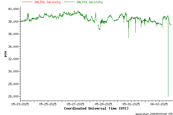
Nueces Delta
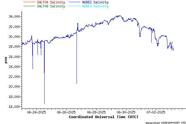
Nueces Bay Proper
Nueces Bay Water Quality Monitoring
![]() Sponsored by: The City of Corpus Christi
Sponsored by: The City of Corpus Christi
With the building of the Choke Canyon Reservoir on the Nueces River in 1985, it was recognized that the natural flow of freshwater from the Nueces watershed into Nueces Bay would be reduced to the point where some water management action would be necessary. The City of Corpus Christi and three state agencies, the Texas Parks and Wildlife Department, the Texas Natural Resources Conservation Commission, and the Texas Water Development Board, studied the problem and decided to take action to alleviate potential problems, namely, ensuring water flows that approximate the natural flows into Nueces Bay. The City of Corpus Christi and the Conrad Blucher Institute have been monitoring water quality in the Nueces Bay since November 1991 to study the effects of this management approach. The Nueces River Authority produces a daily report showing the water levels of the Choke Canyon and Lake Corpus Christi Reservoirs.
More Information
Nueces Delta Water Quality Monitoring
![]() Sponsored by: Coastal Bend Bays & Estuaries Program
Sponsored by: Coastal Bend Bays & Estuaries Program
Normally, a river flows through a delta area prior to making its confluence with its receiving water body. The Nueces River is different in that it flows into Nueces Bay at a point along the south shore of the bay, 2 ½ to 3 miles from the delta-bay interface, completely bypassing the Nueces Delta. Only during times of severe flooding, causing over-banking of the river, or locally heavy rain, does significant freshwater make it into the delta proper. To provide more freshwater diversions to the Nueces Delta during normal flow conditions, the City of Corpus Christi had a pipeline and pump station built to divert up to the first 3000 acre-feet of pass through per month from above the saltwater barrier dam directly into the Nueces Delta via the upper Rincon Bayou. The Conrad Blucher Institute monitors the freshwater inflows coming into the delta via the pipeline by reporting real-time salinities within the water column at various stations along the Rincon Bayou and maintains a real-time weather station. These instruments will be used to calculate spatial and temporal environmental effects as well as the amount of freshwater needed to manage a healthier estuary.